
Ταξιδιωτικός Οδηγός του/της Manos & Stella
Αξιοθέατα
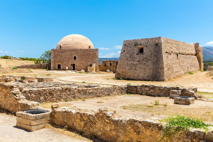
The Fortezza (Greek: Φορτέτζα, from Italian for "fortress") is the citadel of the city of Rethymno in Crete, Greece. It was built by the Venetians in the 16th century, and was captured by the Ottomans in 1646. By the early 20th century, many houses were built within the citadel. These were demolished after World War II, leaving only a few historic buildings within the Fortezza. Today, the citadel is in good condition and is open to the public.
541 سكان محليون يوصون بهذا
قلعة فورتيزا
The Fortezza (Greek: Φορτέτζα, from Italian for "fortress") is the citadel of the city of Rethymno in Crete, Greece. It was built by the Venetians in the 16th century, and was captured by the Ottomans in 1646. By the early 20th century, many houses were built within the citadel. These were demolished after World War II, leaving only a few historic buildings within the Fortezza. Today, the citadel is in good condition and is open to the public.
Lake Kournas is a lake on the island of Crete, Greece, near the village of Kournas. It is in the Apokoronas municipality of Chania regional unit close to the border with Rethymno regional unit, 47 km from the town of Chania. Kournas is a fairly large village perched on a hill overlooking the lake.
361 سكان محليون يوصون بهذا
بحيرة كورناس
Lake Kournas is a lake on the island of Crete, Greece, near the village of Kournas. It is in the Apokoronas municipality of Chania regional unit close to the border with Rethymno regional unit, 47 km from the town of Chania. Kournas is a fairly large village perched on a hill overlooking the lake.
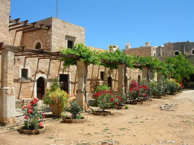
The Arkadi Monastery (in Greek: / Μονή Αρκαδίου) is an Eastern Orthodox monastery, situated on a fertile plateau 23 km (14 mi) to the southeast of Rethymnon on the island of Crete in Greece.
The monastery played an active role in the Cretan resistance of Ottoman rule during the Cretan revolt of 1866. 943 Greeks, mostly women and children, sought refuge in the monastery. After three days of battle and under orders from the hegumen (abbot) of the monastery, the Cretans blew up barrels of gunpowder, choosing to sacrifice themselves rather than surrender.
262 سكان محليون يوصون بهذا
Arkadi
The Arkadi Monastery (in Greek: / Μονή Αρκαδίου) is an Eastern Orthodox monastery, situated on a fertile plateau 23 km (14 mi) to the southeast of Rethymnon on the island of Crete in Greece.
The monastery played an active role in the Cretan resistance of Ottoman rule during the Cretan revolt of 1866. 943 Greeks, mostly women and children, sought refuge in the monastery. After three days of battle and under orders from the hegumen (abbot) of the monastery, the Cretans blew up barrels of gunpowder, choosing to sacrifice themselves rather than surrender.
Plakias (Greek: Πλακιάς) is a village on the south coast of the Greek island of Crete, in the Rethymno regional unit, about 21 kilometres south of the city of Rethymno. It is part of the municipality Agios Vasileios, and of the municipal unit Foinikas. It is surrounded by mountains to the north and the Libyan Sea to the south. The name in Greek means "flat", because the town stands on an alluvial fan of material that has washed down the Kotsifou gorge directly to the north . This material has formed along the sea's edge into a long, fine, gold-hued sand beach, which shelves very gradually out into the bay, making it quite safe for swimming and hence, for family holidays.
55 سكان محليون يوصون بهذا
Plakias Beach
Ethnarchou Eleftheriou VenizelouPlakias (Greek: Πλακιάς) is a village on the south coast of the Greek island of Crete, in the Rethymno regional unit, about 21 kilometres south of the city of Rethymno. It is part of the municipality Agios Vasileios, and of the municipal unit Foinikas. It is surrounded by mountains to the north and the Libyan Sea to the south. The name in Greek means "flat", because the town stands on an alluvial fan of material that has washed down the Kotsifou gorge directly to the north . This material has formed along the sea's edge into a long, fine, gold-hued sand beach, which shelves very gradually out into the bay, making it quite safe for swimming and hence, for family holidays.
The gorge is in southwest Crete in the regional unit of Chania. It was created by a small river running between the White Mountains (Lefká Óri) and Mt. Volakias. There are a number of other gorges in the White Mountains. While some say that the gorge is 18 km long, this distance refers to the distance between the settlement of Omalos on the northern side of the plateau and the village of Agia Roumeli. In fact, the gorge is 16 km long, starting at an altitude of 1,250 m at the northern entrance, and ending at the shores of the Libyan Sea in Agia Roumeli. The walk through Samaria National Park is 13 km long, but one has to walk another two kilometers to Agia Roumeli from the park exit, making the hike 15 km long. The most famous part of the gorge is the stretch known as the Gates (or, albeit incorrectly, as "Iron Gates"), where the sides of the gorge close in to a width of only four meters and soar up to a height of almost 300 meters (980 feet). The gorge became a national park in 1962, particularly as a refuge for the rare kri-kri (Cretan goat), which is largely restricted to the park and an island just off the shore of Agia Marina. There are several other endemic species in the gorge and surrounding area, as well as many other species of flowers and birds.
517 سكان محليون يوصون بهذا
Samaria Gorge
The gorge is in southwest Crete in the regional unit of Chania. It was created by a small river running between the White Mountains (Lefká Óri) and Mt. Volakias. There are a number of other gorges in the White Mountains. While some say that the gorge is 18 km long, this distance refers to the distance between the settlement of Omalos on the northern side of the plateau and the village of Agia Roumeli. In fact, the gorge is 16 km long, starting at an altitude of 1,250 m at the northern entrance, and ending at the shores of the Libyan Sea in Agia Roumeli. The walk through Samaria National Park is 13 km long, but one has to walk another two kilometers to Agia Roumeli from the park exit, making the hike 15 km long. The most famous part of the gorge is the stretch known as the Gates (or, albeit incorrectly, as "Iron Gates"), where the sides of the gorge close in to a width of only four meters and soar up to a height of almost 300 meters (980 feet). The gorge became a national park in 1962, particularly as a refuge for the rare kri-kri (Cretan goat), which is largely restricted to the park and an island just off the shore of Agia Marina. There are several other endemic species in the gorge and surrounding area, as well as many other species of flowers and birds.
Super Market
ΑΒ Βασιλόπουλος
110 Leof. Emmanouil PachlaLidl
17 KaisareiasΦαγητό
Taverna Galera
93 StamathioudakiAchinos Rethymno
33 NearchouTaverna Zisis
63 Leof. Machis KritisTaverna Klimataria
31 Leoforos Machis KritisBeach bars
Baja Beach
12 ChiouBORA BORA
42 Ari VelouchiotiCopaCabana Beach
45 Ari VelouchiotiBrunch coffee bar
Coffee House-Shisha | Bar-Restaurant
𝗖𝗹𝘂𝗯|𝗨𝗽𝗯𝗲𝗮𝘁 𝗜𝗻𝗱𝗼𝗼𝗿 𝗥𝗵𝘆𝘁𝗵𝗺𝘀|𝟮𝟮:𝟯𝟬 🍓🍓
206 سكان محليون يوصون بهذا
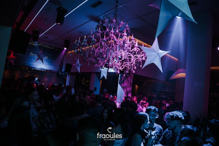
Fraoules
62 Eleftheríou VenizélouCoffee House-Shisha | Bar-Restaurant
𝗖𝗹𝘂𝗯|𝗨𝗽𝗯𝗲𝗮𝘁 𝗜𝗻𝗱𝗼𝗼𝗿 𝗥𝗵𝘆𝘁𝗵𝗺𝘀|𝟮𝟮:𝟯𝟬 🍓🍓